About the Surveying & Mapping Services in Ohio Market Research Report
What’s Included in the Surveying & Mapping Services in Ohio Market Research Report
Definition of the Surveying & Mapping Services in Ohio?
Companies in this industry perform surveying and mapping services on the surface of the earth, including the sea floor. These services include surveying and mapping areas above or below the earth's surface, such as creating view easements or segregating rights in parcels of land by building underground utility easements, which give certain rights to real property without possessing it.
What’s included in the Surveying & Mapping Services in Ohio?
The Surveying & Mapping Services in Ohio includes topographic surveying and mapping services, planimetric surveying and mapping services, hydrographic and bathymetric surveying and mapping services, boundary, property line and cadastral surveying and mapping services, subdivision layout and design services, construction surveying services, geodetic surveying and ground control support services, providing geospatial processing services, providing engineering services and providing landscape architecture services. Related terms covered in the Surveying & Mapping Services in Ohio industry report includes the process of establishing ground control, providing construction control and setting out and undertaking cadastral surveys. specialized equipment is used for very high-precision industrial surveys, a survey related to boundaries and the subdivision of land, the production of maps, including construction of projections, design, compilation, drafting and reproduction, a survey that measures, describes and maps the surface waters of the earth and an activity that involves determining geometric properties of objects based on photographic images.
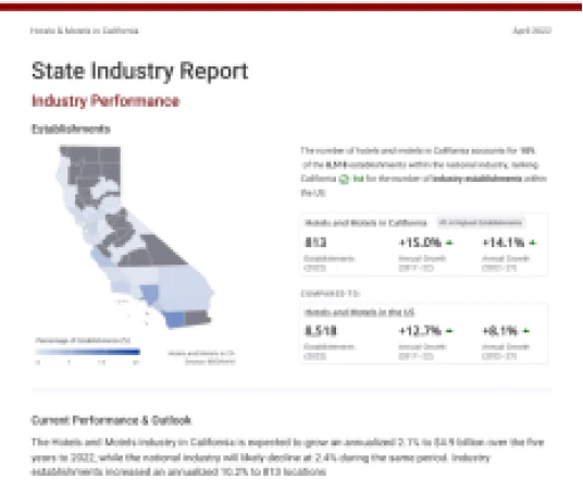
Industry Performance of the Surveying & Mapping Services industry in Ohio
Benchmark the Surveying & Mapping Services in Ohio industry performance with all OH county and national performance.
Surveying & Mapping Services in Ohio
#12 in Highest Revenue 2.7% of state's GDPRevenue (2026)
Annual Growth (2021-26)
Annual Growth (2026-31)
Surveying & Mapping Services in the US
Revenue (2025)
Annual Growth (2020-25)
Annual Growth (2025-30)
For the full list of industry drivers, see report purchase options.
Key Drivers of the Surveying & Mapping Services industry in Ohio
See how key industry drivers, such as population, new business formation, per capita disposable income, local and state government investment, value of private nonresidential construction and government funding for highways are impacting Surveying & Mapping Services in Ohio
Ohio Economic Indicators
Population
New Business Formation
Per Capita Disposable Income
View more economic information in OH State Economic profile
US Key External Drivers
Local and state government investment
Value of private nonresidential construction
Government funding for highways
For the full list of industry drivers, see report purchase options.
County Data of the Surveying & Mapping Services industry in Ohio
Access proprietary data on county in the Surveying & Mapping Services in Ohio, such as Cuyahoga County, Franklin County and Montgomery County. Data includes figures on revenue, establishments, employees and wages by counties.
Key Statistics of the Surveying & Mapping Services industry in Ohio
Download 19 years of historical data and 5 years of projected performance.